
Facts and figures
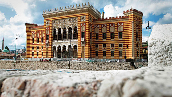
Sarajevo (/ˌsærəˈjeɪvoʊ/; Cyrillic: Сарајево, pronounced [sǎrajeʋo]; see names in other languages) is the capital and largest city of Bosnia and Herzegovina, with a population of 275,524 in its administrative limits. The Sarajevo metropolitan area, including Sarajevo Canton, East Sarajevo and nearby municipalities, is home to 555,210 inhabitants. Nestled within the greater Sarajevo valley of Bosnia, it is surrounded by the Dinaric Alps and situated along the Miljacka River in the heart of the Balkans.
Sarajevo is the political, financial, social and cultural center of Bosnia and Herzegovina, a prominent center of culture in the Balkans, with its region-wide influence in entertainment, media, fashion, and the arts.
Due to its long and rich history of religious and cultural diversity, Sarajevo is sometimes called the “Jerusalem of Europe” or “Jerusalem of the Balkans”. It is one of only a few major European cities which have a mosque, Catholic church, Orthodox church and synagogue in the same neighborhood. A regional center in education, the city is home to the Balkans first institution of tertiary education in the form of an Islamic polytechnic called the Saraybosna Osmanlı Medrese, today part of the University of Sarajevo.
Although settlement in the area stretches back to prehistoric times, the modern city arose as an Ottoman stronghold in the 15th century. Sarajevo has attracted international attention several times throughout its history. In 1885, Sarajevo was the first city in Europe and the second city in the world to have a full-time electric tram network running through the city, following San Francisco. In 1914, it was the site of the assassination of Archduke Franz Ferdinand of Austria by local Young Bosnia activist Gavrilo Princip that sparked World War I, which also ended Austro-Hungarian rule in Bosnia and resulted in the creation of the Kingdom of Yugoslavia. Later, after World War II, the establishment of the Socialist Republic of Bosnia and Herzegovina within the Second Yugoslavia led to a massive expansion of Sarajevo, the constituent republic’s capital, which culminated with the hosting of the 1984 Winter Olympics marking a prosperous era for the city. However, after the start of the Yugoslav Wars, for 1,425 days, from April 1992 to February 1996, the city suffered the longest siege of a capital city in the history of modern warfare, during the Bosnian War and the breakup of Yugoslavia.
Sarajevo has been undergoing post-war reconstruction, and is the fastest growing city in Bosnia and Herzegovina. The travel guide series Lonely Planet has named Sarajevo as the 43rd best city in the world, and in December 2009 listed Sarajevo as one of the top ten cities to visit in 2010. In 2011, Sarajevo was nominated to be the European Capital of Culture in 2014, and has recently hosted the European Youth Olympic Festival in 2019.
Cityscape
Sarajevo is close to the center of the triangular shape of Bosnia and Herzegovina in southeastern Europe. Sarajevo city proper consists of four municipalities (or “in Bosnian and Croatian: općina, in Serbian: opština”): Centar (Center), Novi Grad (New City), Novo Sarajevo (New Sarajevo), and Stari Grad (Old City), while Metropolitan area of Sarajevo (Greater Sarajevo area) includes these and the neighboring municipalities of Ilidža, Hadžići, Vogošća, and Ilijaš.
The Miljacka river is one of the city’s chief geographic features. It flows through the city from east through the center of Sarajevo to west part of city where eventually meets up with the Bosna river. Miljacka river is “The Sarajevo River”, with its source (Vrelo Miljacke) 2 kilometres (1.2 miles) south of the town of Pale at the foothills of Mount Jahorina, several kilometers to the east of Sarajevo center. The Bosna’s source, Vrelo Bosne near Ilidža (west Sarajevo), is another notable natural landmark and a popular destination for Sarajevans and other tourists. Several smaller rivers and streams such as Koševski Potok also run through the city and its vicinity.
The Metropolitan area was reduced in the 1990s after the war and the Dayton-imposed administrative division of the country, with several municipalities partitioned along the border of the newly recognised Federation of Bosnia and Herzegovina (FBiH) and Republica Srpska (RS), creating several new municipalities which together form the city of Istočno Sarajevo in the Republica Srpska: Istočna Ilidza, Istočno Novo Sarajevo, Istočni Stari Grad, Lukavica, Pale (RS-section), and Trnovo (RS-section), along with the municipality of Sokolac, which was not traditionally part of the Sarajevo area and was not partitioned.
The city has an urban area of 1,041.5 square kilometers (402.1 sq mi). Veliki Park (Great park) is the largest green area in the center of Sarajevo. It’s nestled between Titova, Koševo, Džidžikovac, Tina Ujevića, and Trampina Streets and in the lower part, there is a monument dedicated to the Children of Sarajevo.
Climate
Sarajevo has a humid continental climate (Dfb). Sarajevo’s climate exhibits influences of oceanic zones, with four seasons and uniformly spread precipitation. The proximity of the Adriatic Sea moderates Sarajevo’s climate somewhat, although the mountains to the south of the city greatly reduce this maritime influence. The average yearly temperature is 10 °C (50 °F), with January (−0.5 °C (31.1 °F) on average) being the coldest month of the year and July (19.7 °C (67.5 °F) on average) the warmest.
The highest recorded temperature was 40.7 °C (105 °F) on 19 August 1946, and on 23 August 2008 (41.0) while the lowest recorded temperature was −26.2 °C (−15.2 °F) on 25 January 1942. On average, Sarajevo has 7 days where the temperature exceeds 32 °C (89.6 °F) and 4 days where the temperature drops below −15 °C (5 °F) per year. The city typically experiences mildly cloudy skies, with an average yearly cloud cover of 45%.
The cloudiest month is December (75% average cloud cover) while the clearest is August (37%). Moderate precipitation occurs fairly consistently throughout the year, with an average 75 days of rainfall. Suitable climatic conditions have allowed winter sports to flourish in the region, as exemplified by the Winter Olympics in 1984 that were celebrated in Sarajevo. Average winds are 28–48 km/h (17–30 mph) and the city has 1,769 hours of sunshine.
Demographics
The last official Yugoslav census took place 1991 and recorded 527,049 people living in the city of Sarajevo (ten municipalities). In the settlement of Sarajevo proper, there were 416,497 inhabitants. The war displaced hundreds of thousands of people, a large majority of whom have not returned.
The first census since Bosnia and Herzegovina became an independent country was not taken until 2013 and as a result, for many years Sarajevo’s population was not known clearly and statistics were based on estimates contributed by the United Nations Statistics Division and the Federal Office of Statistics of the Federation of Bosnia and Herzegovina, among other national and international non-profit organizations. As of June 2011, the population of the city’s four municipalities was estimated to be 411,161, whereas the Sarajevo Canton population was estimated at 578,757. With an area of 1,280 square kilometres (490 sq mi), Sarajevo has a population density of about 2,173 inhabitants per square kilometre (5,630/sq mi). According to these estimates, the Novo Sarajevo municipality is the most densely populated part of Sarajevo with about 7,524 inhabitants per square kilometre (19,490/sq mi), while the least densely populated is the Stari Grad, with 2,742 inhabitants per square kilometre (7,100/sq mi).
In June 2016, the final results of the 2013 census were published. According to the census, the population of the Sarajevo Canton was 413,593, with 55,181 residents in Centar Sarajevo, 118,553 in Novi Grad, 64,814 in Novo Sarajevo and 36,976 in Stari Grad.
The war changed the ethnic and religious profile of the city. It had long been a multicultural city, and often went by the nickname of “Europe’s Jerusalem”. At the time of the 1991 census, 49.2 per cent of the city’s population of 527,049 were Bosniaks, 29.8 percent Serbs, 10.7 percent Yugoslavs, 6.6 percent Croats and 3.6 percent other ethnicities (Jews, Romas, etc.). By 2002, 79.6 per cent of the canton’s population of 401,118 were Bosniak, 11.2 percent Serb, 6.7 percent Croat and 2.5 percent others (Jews, Romas, Arabs, etc.).
According to academic Fran Markowitz there is a number of “administrative apparatuses and public pressures that push people who might prefer to identify as flexible, multiply constituted hybrids or with one of the now unnamed minority groups into one of the three Bosniac-Croat-Serb constituent nations”. These include respondents being encouraged by census interviewers to identity as belonging to one of the three constituent peoples. Her analysis of marriage registration data shows, for instance, that 67 per cent of people marrying in 2003 identified as Bosniak or Muslim, which is significantly lower than the 79.6 per cent census figure from 2002 (unlike the census, where people respond to an interviewer, applicants to the marriage registry fill in the form themselves).